


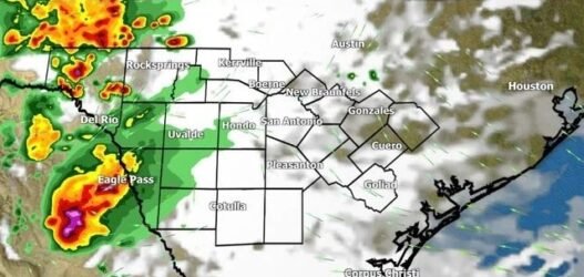
San Antonio and surrounding areas should prepare for another round of showers and thunderstorms moving in from the west this evening. These storms are expected to arrive in waves, with isolated to scattered severe thunderstorms possible throughout the night.
The main threats from these storms include large to very large hail, damaging winds, and an isolated tornado risk. Additionally, some areas may experience localized flash flooding, especially where heavy rainfall has already saturated the ground.
Unlike previous systems that developed to the north and moved southward, this storm setup is different. This time, storms are forming west of the viewing area due to an upper-level disturbance moving into West Texas. As these storms move eastward, their exact impact on the region depends heavily on how they evolve. 
There are two possible scenarios:
-
If storms remain in scattered clusters, some areas may avoid significant weather while others could face intense conditions.
-
If the storms organize into a solid line, widespread rainfall and severe weather could occur, with strong wind becoming the primary hazard and hail remaining a secondary concern.
Forecast models show the storms moving at a steady pace late tonight, limiting the overall risk of flash flooding. However, with already saturated soils from previous rain, even brief heavy downpours could lead to localized flooding.
By 11:00 PM, radar suggests that storms will be moving across the area with strong wind gusts and hail possible. If storm progression slows, impacts may linger into the early morning hours, potentially affecting the morning commute with wet roads and patchy rain.
Residents are urged to monitor local forecasts, stay weather-aware through the evening and overnight hours, and be prepared for rapidly changing conditions. Ensure your devices are charged, and warnings are enabled in case alerts are issued overnight.
Stay tuned to trusted weather sources for live updates as meteorologists continue to monitor radar trends closely. The situation remains fluid, and updates will be provided as conditions change.